Easter Island is one of my favorite destinations and I always enjoy coming here. It never gets old to me. The geology is well displayed and itself is worth a visit. But it is the volcanic rock statues of course and the history they embody that is the main attraction.
As is typical on these private jet trips, we were able to fly around the island for some sightseeing before landing! Imagine using a Boeing 757 for flight-seeing. Here are the statues at Tongariki from 1600 feet on our fly-around. Close-ups of this site will be featured at the end of the post.
The Ranu Raraku tuff cone is where 95% of the statues were quarried (located at the base of the cliff on the far right side). Stratification in the cone remnant suggests that most of it has ben eroded away and that the visible portion is merely the left hand one-fourth of the former cone, which would have extended farther to the right. A second tuff cone formed later and is now filled with water and can be partially seen behind the cliff.
Three shield volcanoes are present on the island and this is Teravaka, the highest shield at about 1600 feet. The eruptions began about 2.5 Ma and emerged above sea level by about 780,000 years ago. The three shields are thought to have been separate islands before their distal flows merged to create the island we know today.
The airstrip was constructed in the mid-1960's and was lengthened in the 1980's to two miles in order to accommodate an emergency landing for the space shuttle (it was never needed). Modern tourism to the island began with the construction of this airstrip. Now there are flights every day from Santiago - note the jet on the tarmac). When I first came here in 1995 there were only two flights per week.
On the north side of the island are three
trachyte domes. Trachyte is a feldspar-rich type of volcanic rock containing about 65% silica. Note the dike leading to the dissected dome and exposed in the sea cliff. This concludes the air tour of the island - what a treat!
Our first stop on the ground was at
Akivi Ahu on the flanks of the Teravaka shield volcano. It contains many celestial attributes regarding a solar calendar used by the islanders (see the link above). Most statues are about this size although they become bigger with time on the island.
Next stop was Tahai on the west coast and close to the only town on the island, Hanga Roa. This site was dug and restored in 1974 by the famous Easter Island archaeologist, Dr. William Mulloy of the University of Wyoming.
This moai was found with the remains of its eyes near the base and so were restored by Dr, Mulloy.
We always have entertainment at the end of our tours and these musicians performed right on the beach where a large tent was set up with fresh fruit sticks, fruit juice and champagne.
Huge waves crashed nearby on the shore and were from a recent storm.
Ranu Kao is another shield volcano that contains a large caldera on its crest. The diameter of the caldera is one mile across.
The famous island of
Motu Nui where the Bird Man competition was held from about 1680 until 1867. See the link for details on this interesting aspect of the islands history.
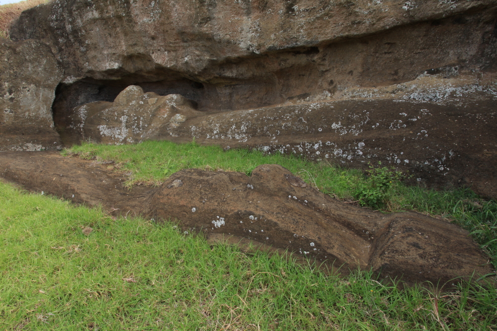
We finally made our way to the eastern side of the island and the quarry site at Ranu Raraku. By the 1800's all of the statues had been toppled and their heads became severed in the fall. This statue has not been restored.
Ranu Raraku is where most of the well-known photos of Easter Island are taken since this was the statue "factory" and over 30 of them are nearby (over 900 statues are known on the island). These two are complete statues but have been buried in eroded material from the cliff above. The Easter Islanders stopped making statues sometime in the late 17th century and this is how much infill has occurred since that time.
They are truly amazing to see!
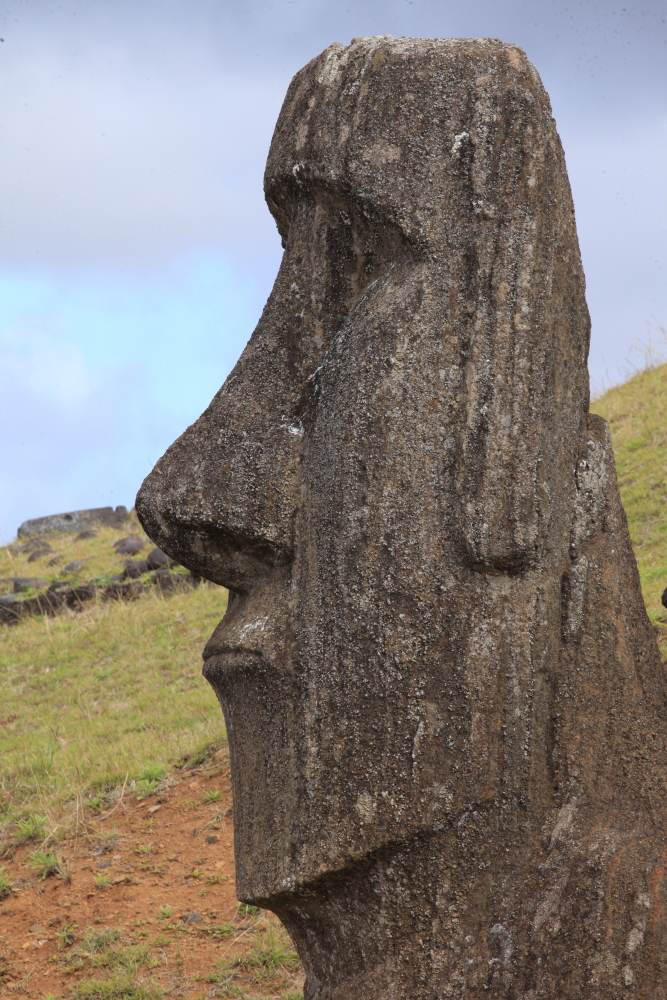
Close-up of a moai at Ranu Raraku.
This volcano is a tuff cone and the geologic conditions were just right to create the perfect carving stone. Lapilli (small volcanic fragments) were erupted in water (likely sea water) to create a
palagonite rock. The papilla are not welded to any great extent so it might have taken 8 men only about a year to sculpt of a statue between 20 and 30 feet high.
Here are two statues that were near completion before work on them stopped in the late 17th century.
The hillside is pock-marked with places where statues were quarried. In the old days we walked everywhere over the site. Today much of it is roped off, which is probably a good thing with the numbers of people who come here now. But I am glad I got to have those other experiences as well.
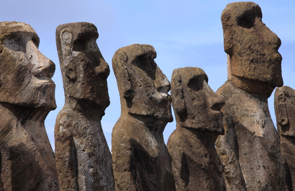
A good view of the Ranu Raraku tuff cone with a moai guardian near the site called
Tongariki.
This is the site shown in the very first photograph of this post. 15 statues line the ahu (altar).
Of course, the statues were lying prone where discovered. In May 1960. a tsunami from the great Valdivia Chile earthquake sent the statues further inland. A Japanese benefactor who had visited the site shortly thereafter donated $2,000,000 and huge crane to help Cladio Cristino restore them to this position.
The detail of preservation is outstanding and the sunlight cooperated well for the photographers in our group.
This was the main ceremonial center for the eastern confederation during pre-historic times.
I feel so lucky to be able to see these fantastic sites! Now it's on to the Great Barrier Reef in northern Australia.


WOW!
ReplyDeleteTruly amazing Wayne.
Since I'll probably never get there,
I more appreciate the feeling you've given me of being there.
I've seen photos before but not so well presented.
Thanks!